Thursday, September 29, 2011


This is a nice shot of me and Guido at School Hut (15,000')
the day before our summit attempt.

Wednesday, September 28, 2011

Looking Back

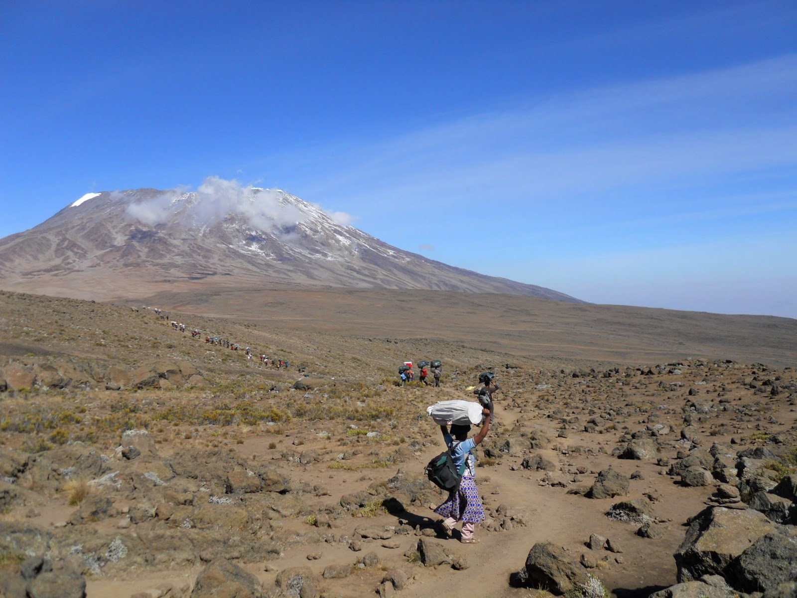
One last look back at Kilimanjaro and Uhuru Peak.  This shot was taken the morning of day three.  We summitted three days later, walking past those specks of white, that turned into colossal sized glaciers at the top.

Heading Home

It was an amazing trip.  We all made it to the top of Kilimanjaro and will have stories and memories to last a lifetime.  What an adventure.  If Kilimanjaro is on your list, definitely do it.  You will never really have enough time or money to do it, but make it happen!!  It is worth it.

Tuesday, September 27, 2011

Maassai Boma

On our way back from the Tarangire Safari, our guide dropped us off at a Maassai Boma to visit with the villagers.  It was another great expeience.  If you get a chance to do this as an add-on to one of your safaris, definitely take the opportunity.  It was fasinating.

Tarangire Safari

This was the best safari of the entire trip.  There were so many animals in this park it was amazing.  The best part was hanging out with this clan of lions.  There were two adult females and about six cubs of varying ages.  It was amazing to just sit and watch them.  We were also lucky enough to see one of the lions chase a water buck...which she didn't catch, but it was exciting, nonetheless.  I would spend an extra day visiting this park if we had it to do again.

Monday, September 26, 2011

Lake Manyara Safari

We had planned for today to be a rest day, thinking we would be tired from the trek.  Instead, we were restless, so we called Team Kilimanjaro and scheduled a last-minute day safari out to Lake Manyara.  Despite being the safari-from-hell with our driver taking us on a couple hours of personal errands before heading out to the park, I'm glad we did it.  Although it was the dry season, we still saw lots and lots of wildlife, including some really close encounters with elephants, zebras and giraffes.

Sunday, September 25, 2011

Moivaro Village Walk

Before our retreat back to the Kibo Palace, we did a walking tour with a guide who showed us the people and back alleys of Moivaro.  It was a wonderful experience.  The kids were great and really friendly.  They tried on Mary's glasses and just thought it was hilarious.  They also liked to see the photos of themselves in the camera viewfinder.  I'm really glad we took the time to do the tour.

Moivaro Coffee Lodge

For our post-trek splurge we booked a little cottage at the Moivaro Coffee Lodge.  Turned out the Moivaro doesn't really have electricity, other than sporadic service every once in awhile (during the day when you really don't need it).  So, we spent one night here and then retreated back to the safety of the Kibo Palace with everyone else.

Saturday, September 24, 2011

Day 7 - Horombo Camp to Marangu Gate

The hike down from Horombo to the Marangu Gate was amazing.  Those trekkers taking the Rongai route up are required to take the popular Marangu route down.  It is a gorgeous route through the most varied vegetation we had seen the entire trip.  The flowers and shrubs at the top above the clouds gave way to dense jungle at the bottom.  It took us about 6 hours to make the 12 mile trek down the mountain.  We were all so glad to see the Marangu Gate, but also a bit melancholy that the great adventure was coming to to a close.  The descent took a toll on everyone's toes, but we were just to be done.  We bought some postcards and enjoyed a cold Coke at the bottom to celebrate.  It was an amazing adventure.  It all seems like a blur now.

Horombo Camp Elevation:  12,185 ft
Marangu Gate Elevation:  6,102 ft
Total Elevation Loss:  6,053 ft
Total Miles:  12.3 miles
Total Time:  6 hours

Friday, September 23, 2011

Day 6 - School Hut to Uhuru Peak

After a couple hours of rest, our guides woke us up at 10pm to get ready for the final assault to the peak.  We left camp around 11pm on a clear and starry night.  The slog to the top was a time warp as my mind focused intently on the each step and then the next.  We could see a trail of headlamps light up the mountainside illuminating every switchback and the interminable climb ahead.  We watched an orange-red moon rise from the darkness...and then the sun rose over Mawenzi just as we reached Gillman's Point.  After some hot tea and a short break, we pressed on to Stella Point.  The last hour or two from Gillman's to the top was the hardest.  I think because it looked so much closer and flatter than it turned out to be.  Despite some headaches, nausea, and clouded vision, the entire group summitted Uhuru Peak around 8am.  It took us 9 hours to get to the top.  It didn't seem that long.  We celebrated our accomplishment for over 20 minutes at the top.  The feeling of success and relief was exhilarating.  It took us another 8 hours of hiking to get down to Horormbo Camp, but the exhilaration carried us through most of the descent.  It was a great day...one we will all remember for a lifetime.

School Hut Elevation:  15,357 ft
Uhuru Peak Elevation:  19,340 ft
Total Elevation Gain:  3,983 ft
Total Time Up:  9 hours
Total Miles Up:  2.3 miles

Horombo Camp Elevation:  12,185 ft
Total Elevation Loss:  7,185 ft
Total Miles:  12.3 miles
Total Time:  17 hours

Thursday, September 22, 2011

Day 5 - Third Cave to School Hut

We had the entire trail from Third Cave to School Hut to ourselves.  It was a beautiful day and the hike seemed a bit easier than expected.  We arrived at School Hut ahead of schedule and rested before an early dinner.  It hailed a bit between the sun and mist.  We are getting used to the constant change in weather which can drop 10 degrees in a matter of minutes.  The expanse of the mountain is setting in and time is more difficult to keep track of.  We are at 15,000 feet now.  Some movements seem more labored, but not excessively so.  The slow going and acclimatization nights have worked well for the group.
Third Cave Elevation:  12,185 ft
School Hut Elevation:  15,357 ft
Total Elevation Gain:  3,172 ft
Total Distance:  5.6 miles
Total Time:  5 hours

Wednesday, September 21, 2011

Day 4 - Mawenzi Tarn to Third Cave

Today we hiked away from Mawenzi towards Kibo across a gentle sloping saddle.  The views of Kibo are amazing.  You can see a light dusting of snow on the mountain indicative of some of the light rain and mist we have been hiking through.  After crossing the saddle to the base of Kibo, we took a spur off the main route and descended to our own private camp at Third Cave.  It was great to be hiking on our own across the great expanse, leaving the crowds behind.  The solitude was palpable.  I don't remember much of Third Cave though as my stomach problems were becoming quite acute.
Mawenzi Tarn Elevation:  14,117 ft
High Point Elevation:  15,137 ft
Third Cave Elevation:  12,185 ft
Total Elevation Gain:  1,020 ft
Total Distance:  6.2 miles
Total Time:  6 hours

Tuesday, September 20, 2011

Day 3 - Kikelewa Camp to Mawenzi Tarn

Today we climbed to Mawenzi Tarn, a camp nestled below the beautiful craggy peaks of Mawenzi.  There is a small stagnant pond used as the water source for this camp.  The hike to Mawenzi Tarn took us about 3 hours.  After lunch we did an acclimatization hike up the slopes of Mawenzi that took us about 1.5 hours.  We are now at 14,000 feet and still feeling pretty good.  I think those training hikes we did in Colorado have really paid off.  Some people that didn't take the diamox are starting to feel the altitude, but overall, everyone is doing well.  It is cold in the mist.

Kikelewa Elevation:  12,070 ft
Mawenzi Tarn Elevation:  14,117 ft
Total Elevation Gain:  2,047 ft
Total Distance:  2.3 miles
Total Time:  3 hours  

Monday, September 19, 2011

Day 2 - Simba Camp to Kikelewa Camp

We got up early today to get ready for a long day of hiking.  We left the crowded Simba Camp to climb the trail with hoards of other people.  I had no idea this route would be so crowded, but we quickly got used to the company and enjoyed eavesdropping on the varied conversations from the eclectic group of trekkers on the mountain.  After 4 hours of hiking, we stopped for a nice lunch at Second Caves (minus 2 chairs that didn't make it).  After lunch, it was another 4 hours of hiking to Kikelewa Camp.  It was a beautiful day, but the clouds were rolling in by the time we reached camp.

Simba Camp Elevation:  8,615 ft
Kikelewa Camp Elevation:  12,070 ft
Total Elevation Gain:  3,455 ft
Total Miles:  7.3 miles
Total Time:  8 hours

Sunday, September 18, 2011

Day 1 - Rongai Gate to Simba Camp

The Rongai route starts out along a dusty wide trail through deforested jungle.  It then passes through some farmland and small villages, before ascending through the low brush heatherland.  You will definitely need your gators for today, as the trail is quite dusty.  We reached Simba Camp just before dark after 4.5 hours of slow hiking.  Unfortunately, the camp was jam-packed full and we had to wait while our porters tried to prepare a site for our tents.  It was dark and cold by the time we rolled into our tents.  It was quite an adventure trying to maneuver in the sloping tent sites.

Rongai Trailhead Elevation:  6,548 ft
Simba Camp Elevation:  8,615 ft
Total Elevation Gain:  2.067 ft
Total Miles:  4.2 miles
Total Time:  4.5 hours

Drive to Rongai Gate

Team Kilimanjaro picked us up bright and early on Saturday morning to head out on our great adventure to climb Kilimanjaro.  They loaded the bags and packs onto the bus and we were off.  Everyone was excited and ready to get on with the climb.  We just had to make it through the 6 hour bus ride to the Rongai trailhead gate, including a stop for last minute supplies at a local mini-mart, and a stop at the Marangu gate for paperwork and permits.  By the time we reached the trailhead, picked the porters, weighed the bags, and ate lunch, I was exhausted.  It was going to be a long day.

Saturday, September 17, 2011

Arusha National Park Safari

The day before our big climb up Kilimanjaro, we did a quick day safari out to Arusha National Park.  Arusha NP is about 45 minutes outside of Arusha and is definitely worth the visit.  This was my favorite safari of the trip, probably because it was my first, but also because of the varied terrain and vegetation.  It was mountainous with thick jungle vegetation as well as open green valleys.  We saw so many animals up close.  My favorites were the giraffes who peered at us curiously through the dense brush.  The baboons were pretty fun to watch as well.

Friday, September 16, 2011

Arusha

This morning we all congregated for breakfast at the hotel. David Squire from Team Kilimanjaro came by around 10am and answered lots of questions that everyone had. It was really helpful to get to talk to him and to have some fears and trepidations dissolved. I feel pretty good about our preparations and am ready to start the adventure. After breakfast and our meeting with David Squire, we all walked into town for a little exploring. Most of the time was spent trying to find an ATM that worked so we could all get some schillings. Ray and David also searched for a sim card for their phones. It was pretty much a circus with the 8 of us trying to walk around. We had crowds of people around us trying to sell us paintings, hats, bracelets, etc. Plenty of guys wanting to show us around as well. It was pretty stifling. We ended up having one guy take us to a touristy market where we bought a few things. We were all back to the hotel by 2pm.  Arusha is nothing to write home about. I'm glad we have a safari scheduled for tomorrow.

Thursday, September 15, 2011

Kibo Palace Hotel

For our pre-trek accommodations, we stayed at the Kibo Palace Hotel in Arusha.  Kibo Palace is amazing and far exceeded my expectations for lodging.  The rooms were big, with marble bathrooms, hot water, floor to ceiling windows, wireless internet, and full time electricity (something we came to appreciate).  The service was friendly and the morning buffet breakfast was great.  I would definitely recommend staying at the Kibo Palace if you want some pampering either before or after your climb. 

Wednesday, September 14, 2011

Travel Days

It took us two days to get to Africa from Salt Lake City. Despite a delay out of Detroit, we managed to make it to Amsterdam on time. Unfortunately, our flight from Amsterdam to Kilimanjaro was delayed as well. Weary eyed, but feeling pretty good, we arrived in Tanzania just after 10pm. The flights were long, but the entire ordeal was not as bad as I thought it would be. Team Kilimanjaro was at the airport waiting for us. After collecting everyone's luggage and organizing the three groups of climbers arriving that night, we headed off into the darkness in a safari type van to find our hotel. By midnight we were checked in to the Kibo Palace Hotel and soon thereafter collapsed into bed.

Tuesday, September 13, 2011

We Leave Tomorrow!

This is my last posting before the great adventure.  We leave for Kilimanjaro tomorrow morning.  I am so excited.  I am also a bit nervous, but hope that the entire adventure goes well.  I was doing some last minute shopping at the Patagonia store, and my friend Paul said to remember the quote: "If something doesn't go wrong, it is not an adventure."  I guess that is a pretty good way to look at it.  Things never really go exactly as planned.  Mary mentioned a similar quote she heard this week:  "There is the trip you plan, and then there is the trip you take."  I have planned.  I have trained.  I have worried.  I am ready for whatever the trip brings.  

Saturday, September 10, 2011

BMI

I recently checked out my body mass index, body fat percentage and other interesting facts.  Here is the summary of my construction after a summer of training. 

Weight:  119.8 lbs
Body Fat Percentage:  17.1%  (low)
Body Water Percentage:  60.5%  (medium-high)
Bone Mass Percentage:  5.5%  (low)
Body Mass Index:  18.8  (low)

Sunday, September 4, 2011

Mt. Democrat, Colorado

For our second day in Colorado we decided to hike Mt. Democrat.  Mt. Democrat is located at the same trailhead as the Mt. Lincoln, Mt. Cameron, and Mt. Bross hike that we did in July.  We didn't do Mt. Democrat at the time, so decided we better go back and get it done.  We drove out to the Kite Lake trailhead the night before and slept in the back of the truck again.  Kite Lake is located at 12,000 ft.  We spent a cold night at altitude and woke up to frost on the windows.  We started the hike around 8 a.m.  It was freezing cold. 


Trailhead Elevation:  12,000 ft
Mt. Democrat:  14,148 ft
Total Elevation Gain:  2,148 ft
Total Miles: 4.2 miles
Total Time:  4 hours

Saturday, September 3, 2011

Quandary Peak, Colorado

We drove to Colorado for the Labor Day  weekend to climb a couple more 14ers before the big Kilimanjaro trip.  The first day we did Quandary Peak outside of Breckenridge.  We slept at the trailhead and started the hike around 7 a.m.  This climb is a haul.  We did the standard route up the east slope, which pretty much follows the ridgeline all the way up.  For some reason, the way DOWN seemed harder than the way up on this one.  The trail was pretty crowded for a Saturday on a holiday weekend.  We managed to make our way up with the masses.

Trailhead Elevation:  10,940 ft
Quandary Peak:  14,265 ft
Total Elevation Gain:  3,325 ft
Total Distance:  6 miles
Total Time:  6:15 hours

Thursday, September 1, 2011

Training Log


Just two more weeks before we head out on the great adventure.  We were only able to get in 40 miles of hiking in August, but we also did quite a bit of road biking for some aerobic cross-training.  I feel as ready as I am going to be.  Looking forward to the big climb!

Sunday, August 28, 2011

Lofty Lakes Loop

We managed to get most of the entire trekking crew out to Utah this weekend for a training hike and overnight in the high Uintas.  We camped at Moosehorn Campground off of the Mirror Lake Highway located at 10,400' elevation.  It was great to spend a night at elevation, especially for those folks coming from sea level.  We took everybody on the Lofty Lakes Loop trail that meanders through some high alpine lakes and passes.  We took the spur out to Cuberant Lake for a mile or so just to add on some mileage.  It was a beautiful hike.  I think this is going to be a great group for the trip!

Trailhead Elevation:  10,100 ft
Lofty Lakes Pass Elevation:  10,913 ft
Total Elevation Gain:  1,300 ft
Total Distance:  6.8 miles
Total Time:  4:45 hrs

Thursday, August 25, 2011

Rongai Route

Here is an estimated summary of our daily hikes and campsite elevations:

Day 1:  Rongai Gate (6,548') to Simba Camp (8,615')
Total Gain:  2,067 ft
Total Miles:  4.2 miles

Day 2:  Simba Camp (8,615') to Kikelewa Camp (12,070')
Total Gain:  3,455 ft
Total Miles:  7.3 miles

Day 3:  Kikelewa Camp (12,070') to Mawenzi Tarn (14,117')
Total Gain:  2.047 ft
Total Miles:  2.3 miles

Day 4:  Mawenzi Tarn (14,117') to High Point (15,137') to Horombo Camp (12,185')
Total Gain:  1,020 ft (2.2 miles)
Total Loss:  2,952 ft (4.0 miles)
Total Miles:  6.2 miles

Day 5:  Horombo (12,185') to Barafu Huts (15,357')
Total Gain:  3,172 ft
Total Miles:  5.6 miles

Day 6:  Barafu Huts (15,357') to Uruhu Peak (19,340') to Horombo (12,185')
Total Gain:  3,983 ft (2.8 miles)
Total Loss:  7,185 ft (9.3 miles)
Total Miles:  12.1 miles

Day 7:  Horombo (12,185) to Marangu Gate (6,102')
Total Loss:  6,053 ft
Total Miles:  12.3 miles

Saturday, August 20, 2011

Ruth Lake

After doing Bald Mountain, we decided to hike out to Ruth Lake for a little more time in the mountains. The hike to Ruth Lake from Mirror Lake Highway is less than a mile, but it is beautiful.  About 15 minutes into the hike we saw a moose and her calf drinking in a babbling brook.  This area really is quite picturesque.  You can also hike in to Ruth Lake from the Lofty Lakes trailhead.  We might try that route the next time.
Start Elevation:  10,120 ft
Ruth Lake Elevation:  10,350 ft
Total Elevation Gain:  230 ft
Total Distance:  1.5 miles
Total Time:  1:15

Bald Mountain

We climbed up Bald Mountain this weekend.  Bald Mountain is at the top of Mirror Lake in the upper Uintas. The top of the peak is 11,943'.  The clouds were a bit ominous for most of the hike, but luckily the rain and thunder storms never appeared.  I couldn't believe how many families and young kids were doing this hike.  It is short, but certainly has its steep and rocky parts that would be difficult for those with short legs.  Anyway, it was a great day.  Even Riley (the little rat terrier) made it to the top.
Trailhead Elevation:  10,700 ft
Bald Mountain Elevation:  11,943 ft
Total Elevation Gain:  1,250 ft
Total Distrance:  4 miles
Total Time:  2:15

Tuesday, August 16, 2011

Fall is Knocking

It is mid-August and I was just complaining last weekend that it was too hot.  What a difference a few days makes.  Last night we took the dogs on a short hike in the foothills and there was definitely a chill in the air.  The cool crisp air felt like fall.  My body instinctively reacted to the cold with the desire to head home and watch some football on TV (or to go shopping for some new school clothes).  It is amazing how quickly the seasons change from one to the next.  The days are getting shorter and the nights and mornings are getting colder.  Let's just hope that summer holds out for our final push for Kilimanjaro.

Monday, August 15, 2011

Protein Powder

I tried a number of different protein powder mixes
and I think the Jay Robb vanilla powder is the best. 
I was getting a little frustrated with my training and felt like I wasn't seeing a lot of improvement in endurance or strength despite the many hiking miles we have put in this summer.  I'm not a self-proclaimed vegetarian, but I don't eat very much meat.  It occurred to me that perhaps I wasn't giving my body the fuel it needed for the training.  So, last week I bought some protein powder packets and starting making fruit smoothies for breakfast every morning.  Each packet provides 25g of protien.  The results so far are really encouraging.  I feel like I have a lot more energy after just one week.  Best of all, I am not as sore after workouts and my chronic achilles problem seems to be getting better!  I would definitely recommend this to anyone starting their training.  I just wish I had started it sooner.  

Sunday, August 7, 2011

Wasatch Crest Trail - Bike Crash

We decided to ride the Wasatch Crest Trail today on our mountain bikes to see how our training is going.  The haul up to Scott's Pass is always a good test of aerobic endurance and lung capacity.  I am pleased to say that we made it all the way up to Scott's Pass without stopping (and without throwing up).  So, I think the training is going well.  Unfortunately, on the way back from Lake Desolation, after feeling overly confident about my riding skills, I tried to make it down a technical rocky patch and went straight over my handle bars.  At some point in mid-air, I actually thought I might land on my feet without damage.  Wishful thinking.  I did land on my feet, but then was pummeled into the rocks and rolled down into the bushes.  My right leg and thigh took most of the brunt force of the fall.  I was able to make it back to the car, but pretty darn beat up.  This stunt will definitely slow down the training!

Saturday, August 6, 2011

Cuberant Lake

We hiked to Cuberant Lake today.  The trail starts from the Pass Lake Trailhead about 32 miles up Mirror Lake Highway.  We started along the Lofty Lakes Loop Trail (going clockwise) and took the Cuberant Lake spur.  It was a beautiful day and the spur off to Cuberant Lake provided some great views of Bald Mountain and Reid's Peak.  The total elevation gain was not that much on paper, but out on the trail, it certainly seemed to be more than expected as we dipped into Reid's Meadow, climbed and descended a craggly pass and then climbed up to Cuberant Lake.

Trailhead Elevation:  10,100 ft
Cuberant Lake Elevation:  10,426 ft
Total Elevation Gain:  800 ft
Total Distance:  6 miles
Total Time:  3.5 hours

Sunday, July 31, 2011

Dog Lake

We finally made it to the upper trails in Millcreek Canyon.  We needed a leisurely hike this afternoon after a busy weekend and Dog Lake is just the ticket.  This hike is about 6 miles roundtrip and provides some great scenary through the aspen and pine trees.  This trail used to be my favorite after-work mountain bike ride.  It stays cool up the canyon even on hot summer days.  The elevation gain is only about 1,200' in 3 miles so the hike feels more like a walk.


Trailhead Elevation:  7,545 ft
Dog Lake Elevation:  8,745 ft
Total Elevation Gain:  1,200 ft
Total Distance:  6 miles
Total Time:  3.25 hours

Sunday, July 24, 2011

Grays Peak, Colorado

For our second hike of the Colorado 14er weekend, we climbed Grays Peak.  This was a beautiful hike through alpine valleys and then up an interminable mountain of gray shale switchbacks.  After our epic day yesterday, I wasn't sure I was going to make it all the way to the top, but the adrenaline kicked in at the end, and before we knew it, we were at the top.  The views from the top looking out over the sea of mountains and peaks was awesome.  It was another amazing day on the trail.  Our spirits run high.


Trailhead Elevation:  11,280 feet
Grays Peak:  14,270 feet
Total Elevation Gain:  3,000 feet
Total Distance:  8 miles
Total Time:  6.5 hours

Saturday, July 23, 2011

Mt. Lincoln, Colorado

We went to Colorado this weekend to try to climb some 14,000' peaks.  We camped at about 9,000' at the Prospector Campground near Dillon, Colorado.  The weekend was a great success and great practice for Kilimanjaro.  I started out too fast for the first climb and got a little winded and a bit nauseous, but as soon as I slowed down, things went pretty smoothly.  We actually did three 14,000' peaks in one day, doing the Mt. Cameron, Mt. Lincoln and Mt. Bross loop from the Kite Lake Trailhead.  It was a beautiful day and a great epic hike.  "Holy Capuchin!"

Trailhead Elevation:  12,000'
Mt. Cameron:  14,239'
Mt. Lincoln:  14,286'
Mt. Bross:  14,172'
Total Elevation Gain:  2,736'
Total Distance:  6 miles
Total Time:  5hrs 50min

Friday, July 15, 2011

Injury Time-Out

Well, I haven't hike for two weeks now.  I think my training schedule was a bit too much and I have succumbed to a bad case of tendonitis in my achilles heel and plantar faciitis on the bottom of my foot.  I have been stretching and icing and trying to let them heal, but no real progress has occurred.  The best treatment for the plantar faciitis seems to be some shoe inserts that redistribute my weight to the balls of my feet rather than the heels.  Ibuprofen works pretty well too.  In the interim, I am training on my road bike.  Let's just hope I can do the training hikes in Colorado next weekend.

Thursday, July 14, 2011

Moivaro Lodge, Arusha

We decided to splurge a little for our post-climb accommodations.  I figure we are going to be tired, so a nice place to relax will be worth the money.  We picked the Moivaro Lodge which is located about 7 km outside of Arusha and surrounded by shamba farms and coffee plantations.  There are about 30 individual cottages for guests and beautiful gardens with a view of Mt. Meru.  

http://www.moivaro.com/


Moivaro Lodge
P.O. Box 11297, Arusha, Tanzania
Tel: +255 27 250 6315/86 or Mobile +255 75 432 4193 (24 hours inc.Sat & Sun)
Fax: +255 27 250 6378

Wednesday, July 13, 2011

Kibo Palace Hotel, Arusha

We finally got our hotels booked through Team Kilimanjaro.  Our preferred choices for something more local and rustic were already booked up, so we ended up at the Kibo Palace Hotel for our pre-climb lodging.  This looks like a pretty nice hotel with some decadent amenities, including wi-fi and coffee in the room.  Kibo Palace is located about five minutes from Arusha town center on the Old Moshi Road, and 45 minutes from the Kilimanjaro Airport.

http://www.kibopalacehotel.com/


Kibo Palace Hotel
P.O. Box 2523, Arusha, Tanzania
Tel:  +255 27 254 4472 / 254 8887
Fax:  +255 27 254 8832

Tuesday, July 12, 2011

Go Local

Well, they always say "go local" and in this case it means "get a tour operator working out of your own country."  The time difference between the US to the UK has been frustrating in trying to get in touch with Team Kilimanjaro when we need to.  It also turns out that we are losing hundreds of dollars on the exchange rate for the trip once all the wire transfers go through and the fees are paid.  In hindsight, I would consider going with a US company next time.

Sunday, July 3, 2011

Bowman Fork

Mary was off to Tennessee for the holiday weekend, so Riley and I were on our own for the hike.  We decided to do the Bowman Fork Trail up Millcreek Canyon.  It was a pretty good choice as there was still a lot of water from the runoff.  We hit snow patches around 8,000'.  We didn't make it to the saddle between Mount Raymond and Gobblers Knob, but we got up pretty high after a couple hours of hiking.


Trailhead Elevation:  6,260 ft
Highest Point:  8,488 ft
Total Elevation Gain:  2,228 ft
Total Distance:  8 miles
Total Time:  4.25 hrs

Sunday, June 26, 2011

Sunset

For our final day in the Uintas we did a quick hike called "Sunset."  We figured this would be a hike to a nice viewpoint for seeing the sunset.  Instead it was a nice hike up an unmaintained and long-deserted logging road to a pond.  The Sunset trail was only on one of our three maps for the area, so it wasn't surprising that it was unmaintained and a bit deteriorated.  We had fun crossing over, under and around lots of fallen trees.  No one else was on the hidden trail.
Trailhead Elevation:  7,400 feet
Sunset Lake:  8,280 feet
Total Elevation:  880 feet
Total Miles:  4.6 miles
Total Time:  2 1/2 hours

Saturday, June 25, 2011

Yellow Pine Creek - Partial

We did a great hike up Yellow Pine Creek in the Uintas.  There is a trailhead for Yellow Pine right off Mirror Lake Highway that we have passed many times.  This weekend we finally stopped and did it!  The trail starts right along Yellow Pine Creek and follows the creek up the canyon crossing it numerous times.  We hit snow at about 8,500 feet elevation.  We hiked through the snow as far as we could trying to follow the trail, but finally had to give up as we couldn't find the sharp left to the traverse.  It was a pretty nice hike with lots of elevation gain. 
Trailhead Elevation:  7,040 feet
High Point:  9,000 feet (when we turned around)
Total Elevation:  2,000 (approximate)
Total Miles:  8 miles
Total Time:  5  hours

Friday, June 24, 2011

North Fork

We went camping in the Uintas this weekend for the first time this season.  Since the snowpack is still pretty high, we selected some lower trails for the weekend.  This is a photo of the Provo River at the crossing along the North Fork trail.  Usually this trail is done as a loop.  Given the massive snowmelt flow in the river, we had to turn around at this point.  This is a nice hike to do after work or on a short day.  Very little elevation gain, but a pretty little hike.
Trailhead Elevation:  7,560 ft
High Point Elevation:  7,710 ft
Total Elevation:  150 ft
Total Miles:  3.6 miles
Total Time:  2 hours


Saturday, June 18, 2011

Thaynes Canyon

We did a great hike up Thaynes Canyon in Millcreek Canyon.  It was Father's Day weekend and the canyon was crazy busy.  Instead of doing our usual hike up Desolation Trail, we decided to head up Thaynes Canyon.  The route up Thaynes is much steeper than Desolation, but it provides a bit of a break from the crowds.  We hiked up the narrow drainage for about 2 miles to the junction with Desolation Trail.  At the junction, we turned right and went about a 1.5 miles on a traverse route that eventually meets up with the Overlook.  From the Overlook, it was another 2.5 miles down to the car.  There was still quite a bit of snow near the top of Thaynes Canyon and across the traverse.  We had to do some route finding through the snow and quite a bit of bushwacking through fallen trees across the trail.  But overall, it was a great day of adventure and solitude off the beaten track of  the Desolation Trail.


Trailhead Elevation:  5,856 ft
Highest Point:  7,635 ft
Total Elevation Gain:  1,779 ft
Total Distance:  6 miles
Total Time:  3.5 hours

Friday, June 17, 2011

The Antennas

One of our early season hikes this year has been the the Antennas.  It is called the Antennas because it follows a dirt maintenance road used to get up to the radio towers installed at the top of the foothills overlooking Salt Lake City.  A portion of the hike actually connects with the Bonneville Shoreline Trail system.  I like this hike because not very many people use this area and it has some great views of the valley and the snow-capped Wasatch Mountains.  On our hike today we saw our first snake of the season.  Mary almost stepped on it because I was telling her to "look up at the beautiful mountains" just before I screamed "snake."  It was a pretty good sized one.  It wasn't a rattlesnake, but looked similar to one. 

Trailhead Elevation:  4,920 ft
City Creek Overlook Elevation: 
Total Elevation Gain:  900 ft
Total Distance:  6 miles
Total Time:  3 hours

Sunday, June 12, 2011

Frying Pan and Cohab Canyon - Partial

We were down in Torrey, Utah, this weekend looking at real estate with some friends.  We managed to get in a great hike on Sunday in Capitol Reef National Park.  We did a portion of the Frying Pan Trail and Cohab Canyon.  The trail starts in the Fruita area of the park and climbs to a great viewpoint of the valley and surrounding mesas.  We hiked up Cohab Canyon and then hiked in on the Frying Pan Trail for about 1/2 mile.  We ran out of time to do more exploring, but we will definitely come back to do this one again.  It was a great way to spend the day with friends.

Trailhead Elevation:  5,436 ft
Overlook Elevation:  5,836 ft
Total Elevation Gain:  1,000 ft
Total Distance:  4 miles
Total Time:  2.5 hours

Saturday, June 4, 2011

Grandeur Peak

We made it to the top of Grandeur Peak today.  It was the first nice weekend of the spring/summer and we made the best of it.  Lots of people were out enjoying the trails.  There was still quite a bit of snow on the trail at the top for the final ascent, but we made it.  We did the hike with our friend Leslie who made sure we got to the top.  It took us about 2 1/2 hours to get to the top and total time was about 4 1/2 hours.  Thanks for a great day on the trail.


Trailhead Elevation:  5,960 ft
Peak Elevation:  8,299 ft
Total Elevation Gain:  2,340 ft
Total Distance:  7 miles
Total Time:  4.5 hours


Saturday, May 28, 2011

Up and Over

We did the Up and Over hike today with some friends, including Maren and Stewart and their new dog Gracie.  I think it was a pretty big hike for Gracie -- who probably had never hiked in her life.  The Up and Over has been our standard "go to" hike this spring while we wait for the upper trails to melt off.  It is a great hike in the foothills above the University of Utah that goes up above Red Butte Creek to Van Cott Peak and down the other side along a ridgeline overlooking the Huntsman Cancer Institute.  We have done this hike over 20 times already this year. 

Trailhead Elevation:  4,990 ft
Peak Elevation:  6,348 ft
Total Elevation Gain:  1,358 ft
Total Distance:  4 miles
Total Time:  2.25 hours

Friday, May 20, 2011

Blood Work Results

Kidney, electrolyte, liver function, thyroid and CBC tests were all normal.  Vitamin D deficiency indicated.  Here are the specific results of the blood work:

Blood Sugar Level:  85 (normal is less than 100)
Cholesterol:  169 (normal is less than 200)
Triglycerides:  54 (normal is less than 154)
HDL Cholesterol:  54 (normal is greater than 50)
LDL Cholesterol:  104 (normal is less than 130)

Wednesday, May 18, 2011

Physical Exam

Well, a trip to Africa and a climb to 19,000 feet seems to be good cause for a general pre-trip check up with the doctor.  I went in yesterday for my first physical exam in probably 5 years.  I forgot how many places they can find to poke and prod.  Even though the trip is still nearly 4 months away, I decided to get in to the doctor sooner rather than later just in case something needs to be addressed.  So far, everything looks good.  I just have to wait to get the blood work back.  Interestingly, it feels reassuring to know that everything looks in order.  I consider myself pretty healthy, so I wasn't expecting to feel any sort of relief.  I guess we all harbor a bit of insecurity and doubt when it comes to our health.  I'm definitely glad I got the "once over" if nothing more than to feel more confident about my health and fitness level.  Anything I can do to add to the confidence level for the trip is a plus in my book.  If you can fit it in to the training regimen, I would definitely recommend adding the physical exam to your preparations for the trip. 

Sunday, May 8, 2011

Observation Point

For our final day in Zion, we hike Observation Point.  This trail twists and turns up Echo Canyon on what seems like an interminable trail.  Maybe we were just tired from all the hiking we had done.  After climbing up the canyon, the trail follows the ridge like a horseshoe to Observation Point.  You can see the destination in the distance.  The wind was howling across the ridge at probably 30 mph gusts.  We didn't get to really enjoy the view with the searing wind, but the point does provide expansive views in all directions.


Trailhead Elevation: 4,360 ft
Observation Point Elevation:  6,507 ft
Total Elevation Gain:  2,147 ft
Total Distance:  8 miles
Total Time:  5 hours

Saturday, May 7, 2011

West Rim Spring

On the same day we did Angels Landing, we ventured out on the West Rim Trail to Cabin Spring.  This trail is epic.  We started out from Scout's Lookout at the base of Angels Landing.  After a brief uphill slog, the trail opened up into Telephone Canyon surrounded by white and red cliffs and cascading waterfalls.  It was just beautiful.  After a few hours, the trail comes to a horseshoe and seems to disappear, only to continue to the ridge on a path literally chiseled out of the cliff face.  It was amazing. 


Trailhead Elevation:  4,297 ft
West Rim Elevation:  6,736 ft
Total Elevation Gain:  2,439 ft
Total Distance:  6 miles
Total Time:  4 hours

Angels Landing

We managed to make it up Angels Landing in Zion NP.  It took me two tries.  The first time I was by myself and chickened out.  The second time I was with Mary and I bought a hat like my friend suggested and DID NOT LOOK DOWN.  I just followed Mary's footsteps up the craggly ridges.  For those of us afraid of heights, this one takes the cake. I'm glad I can say I have done this one!


Trailhead Elevation:  4,297
Angels Landing Elevation:  5,785 ft
Total Elevation Gain:  1,488 ft
Total Distance:  5.4 miles
Total Time:  3 hours

Saturday, April 30, 2011

San Rafael Swell - Again

We made a quick trip down to the Swell to retrieve the T@b.  We did a great hike along the San Rafael River from the Bridge to the mouth of the Little Grand Canyon.  We made it in about 3 1/2 miles and then turned around.  Total time for the hike was about 3 hours 45 minutes.  Minimal elevation gain but some beautiful scenery.

Tuesday, April 26, 2011

Immunizations

I hate getting shots.  But if you are going to travel you are going to have to get poked a few times.  Deciding what immunizations to get and which ones to skip is almost like trying to pick a good mutual fund in a bear market.  The CDC has decent information on their travel website for Tanzania. Then you will want to talk to your own physician or to your physician friends going on the trip with you (handy to have).  At this point I tossed the coin up in the air and decided I would rather be safe than sorry. 

Here is a running list of what I decided to go with for the trip:

3/22/11  Hepatitis A (Twinrix combined shot with Hep B) ($63)
3/22/11  Hepatitis B (Twinrix combined shot with Hep A)
3/22/11  Tetanus, Diphtheria, Pertussis ($37)

4/25/11  Hepatitis A & B (Twinrix combo shot) ($63)
4/25/11  Polio Booster ($39)
4/25/11  Meningococcal ($122)

7/29/11  Typhoid
7/29/11  Yellow Fever